
Routes
2024 COG Rally Updates and Alerts to your Phone |
IMPORTANT NOTE: Cell service may be sparse when riding in West Virginia... this is due partially to the rural and mountainous nature of the area, but mainly the United States National Radio Quiet Zone (surrounding Green Bank Telescope). It is strongly suggested not to rely on smart phone app navigation that requires a cellular data connection to obtain maps datum. Stand alone GPS devices, like a Garmin, will function as expected.
Here is a link to a recent Concourier column by Rick Miller (AAD-WV) for a humorous look at important things to note about riding in WV. < read article >
SAMPLE RALLY ROUTES
There are several sample GPX files (plus a POI file) available in the online GPX Repository on the COG website for you to use for your ride planning. These routes were prepared using Garmin Basecamp. None were ride tested recently for this event. You are downloading them as-is. We encourage you to customized them, as needed, to meet your own needs. RELEASE: As with any route provided, we recommend following the route on a map first. This way you will have a better idea of where you are going and have more fun doing it. Downloading and using any route file indicates you acknowledge that you agree to do so with the understanding that the Concours Owners Group (COG) cannot assume responsibility for your personal safety when using these routes. If you choose to use these routes you do so voluntarily, based on your own assessment of your abilities, route conditions, and facilities, and therefore assume all risks. You release and hold harmless COG, its officers, agents and members from any and all injury and/or loss to your person or property that may result from using these routes or participation in this event. These routes are provided as samples and without any guarantee of accuracy, road quality, or safety. By downloading these route files, you agree to the release statement above.
The mileage and approximate ride time without stops of each loop is provided with each description for planning purposes. |
SAMPLE ROUTE FILE DESCRIPTIONS |
POI GPX This is a GPX file containing many Points of Interest (POI) in the rally area that can be loaded into your GPS to get you directly to a specific location, or they can be used within Basecamp to create your own routes. |
Glenville Loops There are three different loop length options to choose from. All loops share common roads near Flatwoods and pass through Glenville to the northwest, and Ivydale to the southwest. The longer loops extend further northwest. Many of the small towns passes through have places to eat. All routes pass through Nebo WV where the popular Pizza & Cream restaurant is located.
The "extra segments" gpx file provides extra route segments that can be used to customize the routes by combining them with one of the loops to create longer or different rides. | 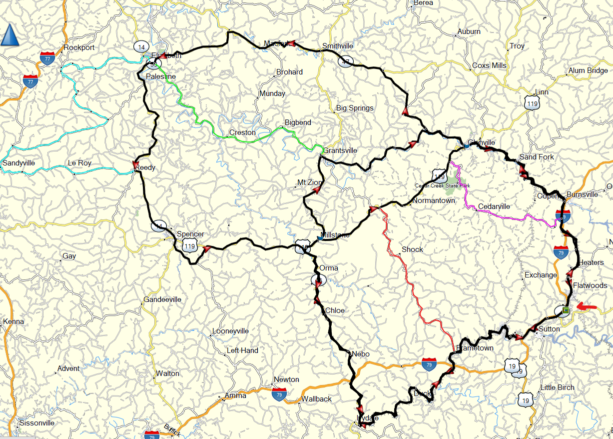 Map shows overlay of all routes. |
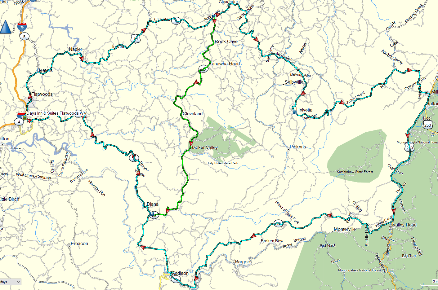
Holly River - Hacker Valley WV Loops Two different length loops to explore around Hacker Valley and beyond. This area was settled by Swiss immigrants. Both loops pass by the Home Town Diner in Diana WV, which has breakfast and lunch service, or seek out other restaurants along the way.
|
maps shows overlay of both loops |
Marlinton WV Loops Two slightly different rides headed southeast from rally central and through Marlinton WV. COG Northeast has been visiting Marlinton area for years for our summer weekend event. This area offers outstanding riding. The loops can be modified to bring you closer to the Cass Scenic Railroad and the Green Bank Observatory Science Center.
|
Map shows the alternate route |
.png)
New River Gorge - Babcock State Park WV Ride This ride heads south to the New River Gorge Bridge. Ride over it and below for awesome views. Don’t miss the Visitors Center at the north end of the bridge. After visiting the gorge, the ride continues to Babcock State Park gristmill and gift shop before returning back. If you have extra time, consider adding a detour south to visit historic Thurmond, WV.
For those interested, the New River Gorge area has some off-road riding areas available. Do a Google search for options. |
|
.png)
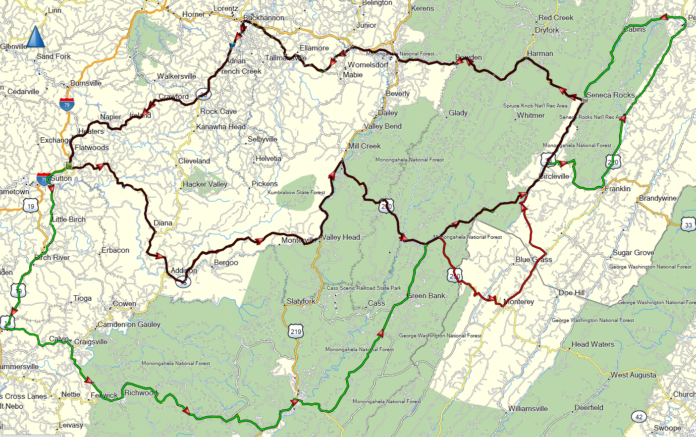
Seneca Rocks WV Loops There are three ride loop options, each progressing in length riding northeast from rally central and taking you to Seneca Rocks, one of the most photographed natural formations in WV.
|
maps show overlay of the 3 routes |
Staunton VA Loop This is the longest sample ride loop. It loops counterclockwise and starts out headed southeast and then northeast to Staunton VA. The return leg is north and west. Staunton VA is a favorite destination of NE COGgers where you can find many great lunch stops in the historic Downtown!
|
|
.png)
Wayne Forest Marietta OH Ride This 340 mile ride heads north toward Marietta OH and around the beautiful Wayne National Forest. To extend you time riding in the Marietta OH area, visit the Windy 9 website: www.windy9.com
|
|
.png)
Webster Springs WV Loop This is a short 84 mile ride headed south through Webster Springs and then back north to Flatwoods. Lunch stop in Webster Springs or at Home Town Diner in Diana WV.
|
|
.png)
Concours Owners Group™ (c) 2022 All rights reserved
The Concours Owners Group is a 501(c)(7) non-profit organization |
|